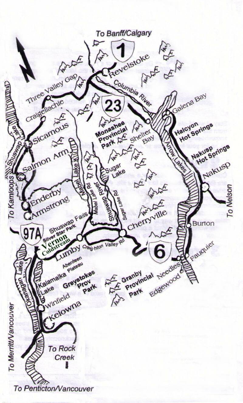
It is here that the Okanagan grasslands, forests and mountains are bound together by the sustenance of life – water. Exploring this eastern edge of the North Okanagan provides adventurers a chance to find worlds hidden within the remote valleys of this place.
This two part Bearfoot Canada series has been produced by the Watershed Intelligence Network in partnership with the Cascadia Conservancy.
PART 1
MAPS
We welcome you to explore with us the Undiscovered Country, a documentary featuring stories and experiences as we journey into the Coldstream and Monashee.
Lake Missoula breaching its ice dam may have been impressive, Young says, but probably not impressive enough to account for the Scablands. “Models of dynamic hydrology suggest that floodwaters from the Missoula Basin alone were insufficient to fill the Scabland coulees, much less do all of the work required to produce the incredible landscapes in the region.”
Instead, Young is looking for a water source from the north, where the massive Cordilleran ice sheet covered much of British Columbia. His attention is on a lobe that buried B.C.’s Okanagan region beneath nearly three kilometres of ice, terminating almost on top of the Scablands south of the Okanagan.
A cataclysmic chain of events originating under this southern B.C. ice, perhaps triggered by volcanic eruptions from below and surface meltwater making its way through the immense ice sheet, would change prevailing theories about one of the greatest flash floods of the last Ice Age.
“The Okanagan and surrounding uplands are part of dramatic landscapes, including landforms carved into bedrock like the Channeled Scablands,” Young says. “Features such as water-eroded channels that can go uphill, and streamlined landforms caused by fluids flowing turbulently at high velocities, all suggest huge flows came out of the Okanagan Valley and drained south into the Columbia drainage.”
He argues that massive volumes of melt water flowing under the Okanagan ice pushed southward -- probably along more than one path. Part exited from the southernmost point of the ice sheet, purging into the Scablands.
More water rushed southeast down the southern Rocky Mountain Trench into Glacial Lake Missoula, and under glaciers emanating from the Purcell range. When the ice dam at Glacial Lake Missoula failed, floodwaters spilled west several hundred kilometres into the Scablands hours or days after the initial onslaught.
Young says the challenge is that, until only recently, sub-glacial reservoirs have not been considered candidates for the kind of catastrophic flooding that created the Scablands.
However, there’s evidence today that huge volumes of water do collect under ice sheets and are released in outbursts of flooding. “Movement of large water volumes of melt water beneath the Antarctic ice sheets have been reported by several researchers in the last few years,” Young points out. “And in Greenland gigatons of water on top of ice sheets have been observed draining through the ice very quickly -- in as little as 48 hours.”
Over several years, he says, water accumulates under the ice and eventually it can lift or “decouple” the ice and flood through any exit it finds. “In Iceland, this process occurs regularly, and is greatly accelerated when intermittent sub-glacial volcanic eruptions occur, causing the reservoir to overfill, and leading to flows many times those normally seen during regular outburst floods,” Young says.
There’s evidence of volcanic eruptions beneath the ice sheet just north of the Okanagan -- in what today is B.C.’s Wells Gray Provincial Park. “Many of the deposits and volcanoes there bear telltale marks of sub-glacial eruption, including pillow basalts on mountainsides and flat-topped volcanoes,” Young says. “Volcanologists studying the region indicate that three volcanoes erupted sub-glacially during the last glaciation.”
Volcanic activity and normal surface melting could eventually produce enough water to decouple the overlying ice and drain catastrophically, says Young.
“With no other sufficient source of water for the Scablands megaflooding, and equipped with several realistic mechanisms for water formation,” he says, “we must consider the Okanagan scenario as a valid alternative to Lake Missoula alone accounting for such a catastrophic event.”
So the question remains, was the great sea a submerged one covered by a thick layer of ice, or had the ice melted forming a much warmer environment in this ancient region?
Had this acient Okanagan lake actually triggered the Great Missoula Flood?
Was McIntyre Bluff near Okanagan Falls the site of a giant ice dam?
Perhaps the historical data has yet to be discovered to give us clear answers. But ancient seashells and coral along the edge of a tiny lake between Lumby and Cherryville may provide further clues about this ancient landscape as well as its first inhabitants.
(30)
a landscape is formed...
An Ancient Glacial Lake
What proof do we have of an extraordinary megaflood?
By Don Elzer
In a UBC Report by Bud Mortenson published in April 2007 he explained a theory by Robert Young an Assoc. Prof. of Geography and Earth and Environmental Sciences at UBC Okanagan that indicates that a great body of water formed over the Okanagan Valley as a result of melting ice sheets.
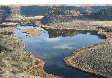
Young’s theory goes even farther, with new evidence suggesting an Ice-Age megaflood that created Washington State’s Channeled Scablands about 15,000 years ago partly originated in south-central British Columbia, not exclusively from Montana as the prevailing theory suggests.
The megaflood’s statistics are staggering. Arriving from the northeast, a wall of water tall enough to leave gravel bars 120 metres high ripped across Washington at 120 kilometres per hour, eroding more than 80 cubic kilometers of earth and rock in two or three days. The torrent left a scoured 25,000-square-km landscape riddled with deep canyons -- known as coulees -- carved out of the hard bedrock.
The question of where all that water came from has been hotly debated for decades,” says Young. Most think the floodwater came from Glacial Lake Missoula, 400 kilometres away in Montana. As big as Lake Ontario and Lake Erie combined, Lake Missoula was held back only by a dam of ice near the Montana-Idaho border. The long-held hypothesis is that when the ice dam broke, the water poured westward with unimaginable fury and destruction.
The Undiscovered Country is a production of the Watershed Intelligence Network.
The Watershed Intelligence Network creates and manages information power tools for a changing planet. Watershed produces online documentaries for broadcast within its own online network as well as other independent and publically owned media outlets.
This documentary series was made possible through individual contributions and sponsorship support by community owned businesses and not-for-profit foundations.
If you would like to support the Watershed Intelligence Network please visit our contribute page.
The content within this documentary series cannot be reproduced without written permission from the Watershed Intelligence Network – please contact us.
This online documentary is available for viewing from September 23rd
to November 30th 2009
The Cascadia Conservancy promotes a healthy and sustainable environment for rural British Columbia. We link the protection and enhancement of natural eco-systems with human settlement that includes a vibrant local economy.
We are a proud partner of this production The Undiscovered Country
Stewardship & Community
Imagine yourself in a cozy cabin on a beautiful meadow at the edge of a secluded lake surrounded by towering forested mountains…
Cozy Cabins Nature Resort
Located at the entrance to Echo Lake Provincial Park