From the Kalamalka Lake Lookout we can see the lush valley bottom of orchards but with the growing encroachment of urban sprawl. The dry barren hills that surrounds life on the valley floor is indicative of the natural world here without water. It is a desert and water is crucial to maintain the life support system for the sun worshipers that dwell here.
Our journey departs this lookout into the Coldstream where life is defined by “rural living at its best” and sometimes used as a war cry to protect the small holdings and farms from an ever expanding suburbia that now defines the Okanagan Valley as one of the fastest growing regions in North America.
The District of Coldstream was incorporated in 1906 and has a total land area of 67.25 square km. The rural district is best known for the Coldstream Ranch, established in 1863 by Captain Charles Frederick Houghton. He transferred the ranch to Forbes G. and Charles Albert Vernon who in 1891 sold it to John Hamilton-Gordon, 1st Marquess of Aberdeen and Temair, future Governor General of Canada (1893-1898).
It was Lord and Lady Aberdeen who would together mastermind the means by which water would be brought to this dry landscape. They would provide the original vision of a lush Garden of Eden which came to be after they spent a fortune investing in the dream.
The ranch was purchased by its current owners in 1994 and continues to be one of the oldest continuing operating ranches in Canada, once representing the farthest edge of settlement in the western wilderness.
Today, the mix of modern rancherettes and stately old homes remain anchored by an idea that the Coldstream Ranch will be there forever. This working ranch is the largest landholder in the North Okanagan and provides a basis for the rural landscape to remain important here.
Kalamalka Lake Road meanders between the edge of thick habitation and orchards; it is the access point to Kalamalka Lake Provincial Park and a ribbon of trails that defines a more natural edge between people and nature. The beaches here still speak of pleasure as the lakeside viewpoints have retained a great deal of the original Okanagan landscape, but they too are at risk as waterfront becomes the new goldrush in this valley.
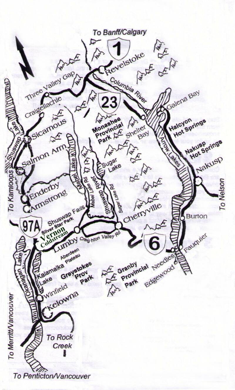
Highway 6 east of Vernon serves as the route into the Monashee and the Upper Shuswap River region. This meandering highway bridges the Okanagan with the Kootenay and is one of the great drives in British Columbia.
On a knoll between Lavington and Lumby on Highway 6 in front of the Tolko White Valley Sawmill, you can get out of your car and place one foot in the Okanagan watershed and the other in the Shuswap, which means you have placed one in the Columbia system and the other in the Fraser.
Lumby
Nestled in a valley surrounded by rich farmland is the quaint town of Lumby, which describes itself as the Gateway to the Monashee. Lumby is located on Highway 6, 22 miles (35 km) east of Vernon and 23 miles (36 km) west of Cherryville. The village is also surrounded by a mix of industrial property that still dispays the rememnts of a once thriving forest industry.
Here the picturesque Coldstream, Trinity and Creighton valleys all converge and it is here where choices can be made to embark into varied landscapes of streams and lakes that beckon the avid outdoors enthusiast to go hiking, canoeing and fishing. In winter, this is a popular spot for cross-country skiing and snowmobiling.
Although the Village of Lumby was incorporated in 1956, its history dates back to 1893, when the forty-acre town site was surveyed. Prior to that, the small settlement of pioneer farmers, loggers and gold miners lived in White Valley, which had its beginning with the discovery of gold at Cherry Creek in 1862.
The gold fever in British Columbia in the early 1860s brought men seeking instant wealth. Some made their fortune and fulfilled their dreams while others quickly squandered their riches. Some were disappointed and disappeared. Some realized the real potential was in the forests and soil of the valley. They became the first settlers. Murals in the village depict the rich forestry and farming history of the area and the Lumby & District Museum has displays detailing the community's colourful distant past.
But the more recent past includes an ample number of "counter culture" characters who were inspired by the area's landscape—American 60's activist Timothy Leary, Joey Kieghley a punk rock legend from the band DOA and Rene Dahinden the famous Sasquatch hunter have all contributed to the spirit of this place; and even Rolling Stone Magazine discovered the area, branding it as growing "best pot in North America”.
The 60's are gone and the area is now home to gentlemen farmers and wealthy retirees, but a sizable artist and artisan community remains - creating everything from landscapes, pottery, and glass sculpture to log homes. Today modern explores seek to mix their weekend quests with a balance of nature, adventure and culture. Discovering an open studio with an artist at work is worth the search.
Side Trips with Adventure
With more and more explorers and gold prospectors heading into the Monashee in the 1800's, a road was built from Lumby to Cherry Creek in 1877. According to the BC Department of Public Works, the route came through Blue Springs Valley, it was about eight feet wide. With a road to the area, families began to arrive; eventually that road became Highway 6 which eventually makes its way to the Arrow Lakes but in between is a collection of country roads emanating from it that includes Mabel Lake Road, Sugar Lake Road and Creighton Valley Road to name a few.
Today, history has carved into the landscape, the rolling countryside is home to farms and forestry operations mixed with the natural landscape to provide travelers with endless options of some of B.C.'s best country drives.
Mabel Lake Road begins as Shuswap Avenue in Lumby and travels north as a paved road that turns to packed gravel as it reaches the south end of Mabel Lake. Here it continues as a secondary gravel road to Three Valley Gap west of Revelstoke. Many visitors compare Mabel Lake Road to the English countryside with rolling farmland and quaint holdings, oozing with the laidback rural lifestyle that the friendly Mabel Lake community is famous for. Shuswap Falls, various show jumping and riding arenas, the Alive Resort and Spa, Mabel Lake Provincial Park, and Landslide Studios are among a few of the sites to be experienced along Mabel Lake travel route.
Creighton Valley Road is a chance to explore a treasure tucked away in the shadows of a rainforest valley. Echo Lake Provincial Park, is a mosaic of color that surrounds a crystal clear lake which inspires imagination with its extreme beauty. Its glass-like surface is only rippled by the movement of families of loons and the Kokanee jumping at feeding time. This road connects Lumby and Cherryville and allows travelers to circle the Camels Hump where cliffs expose an ancient landscape which still present mysteries to this day. A journey round the hump can provide a weekend canoe trip on the lake or down a BC Hydro canoe route on the Shuswap River. Then there’s the possibility of fly-fishing or a round of golf. In Creighton Valley, summer or winter, a cozy stay in a heritage log cabin or lodge is comfort that shouldn't be missed.
Sugar Lake Road the locals call, the real way into the Monashee! At Franks Store and the Cherryville Artisans Shop turn north from Highway 6 into the Monashee foothills. Here too is where the Shuswap River turns north into its headwaters area. This paved road follows the valley bottom where it arrives at Brenda Falls and Sugar Lake. Here a fishing resort can provide you with a great base camp as you make your way into an endless array of wilderness destinations in your quest for snowcapped mountains.
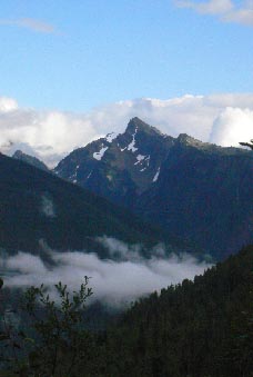
Monashee Provincial Park, the Mark Berger Traverse, The Pinnacles, and Rainbow Falls are a few places that mix old growth rainforests, waterfalls with the Alpine and great wildlife viewing. In the winter this area is becoming known as one of the best backcountry skiing and snowmobiling areas in Canada with a number of great alpine lodges off the beaten path
Cherryville
The vibrant and diverse community of Cherryville is located in the foothills of the Monashee Mountains, on Highway 6 in the North Okanagan, 14 miles (22 km) east of Lumby. Cherryville offers beautiful scenery, fascinating places and features to explore. Cherryville was named after the wild Chokecherries which grow along the banks of Cherry Creek and began as an old gold mining camp founded in the 1860s by prospectors from the California gold rush. Between 1863 and 1895, the original town that we now know as Cherryville was merely a small mining camp located within the canyon walls of Cherry Creek. It boasted a population of nearly 100 people, half of which were Chinese miners. The remains of Chinese workings and water canals are still visible, and historic tours of the Chinese diggings, old mining equipment and mining sites are available aboard the Monashee Stage Bus at the Goldpanner Campground, located at the site of old Cherry Creek.
From Cherryville, Highway 6 meanders through the Monashee to the Arrow Lakes where you will find the communities of Edgwood, Fauquier and Burton before you begin in a northward direction to the hotspring community of Nakusp.
Edgewood
Located 20 km from the Needles Ferry, Edgewood is a small relaxed community, off the beaten path. Forestry and farming are the economic mainstays of the community, with several retail businesses, including the Edgewood General Store, a post office, credit union and Carol's Garden Cafe.
If you are an outdoor enthusiast, you will find plenty of fishing, hiking, hunting, swimming, boating, and biking opportunities in the vicinity.
Several natural attractions pique visitor's interest, including waterfalls, wildlife, and species of birds such as the formidable Bald Eagle and the graceful Osprey. Eagle Creek Provincial Park and Campground, is a great place to view the valley, enjoy a picnic, or just relax on the sandy beach. Boat launching facilities are available.
Fauquier
The village of Fauquier is nestled along the east shore of the Arrow Lakes, where Highway 6 meets the Needles Ferry. Fauquier is a small community of 300 and is known for a presenting a great golf experience. The Fauquier Golf Club's nine-hole course is just yards from the water's edge and ferry landing at Needles. This specatular view of the Arrow Lakes provides a hidden gem for visitors. Wildlife is plentiful here, making hiking and cycling a different adventure every time. Birds of prey, deer, game birds and other animals call the area home. With a boat launch nearby, Fauquier is a favorite spot for anglers, offering impressive sizes of Rainbow Trout.
The Hot Springs Route
Continuing north from Fauquier is the Village of Nakusp where hotsprings can provide travelers with an ideal destination. Visit the Nakusp Hotsprings or take a stoll through this colorfull village, visit the Nakusp Museum, which profiles the town's pioneer history and the sternwheelers that navigated the waters of the Arrow Lakes. For a peaceful retreat, stroll along the Nakusp Waterfront Japanese Garden. From Nakusp you can turn east and travel to Kaslo and Nelson or continue north on Hwy 23 to Halcyon Hotsprings, from here you can cross the lake again by ferry and continue to Revelstoke a small and picturesque city located on the TransCanada Highway, from here access east will lead you to Calgary, while west you can complete a circle drive back to Vernon, or continue west to Kamloops and Vancouver.
The Monashee is an incredible mountain playground. From fine cuisine, to indoor and outdoor excursions, to gorgeous and relaxing walks on the beach, there is always something to do on your own or with friends or family. Whether your idea of exciting recreation is a guided trek to a waterfall, a soak in a wild hotspring, or a relaxed exploration of art or craft the Monashee is a treasure chest of adventures.
(30)