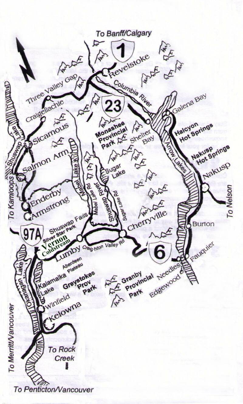
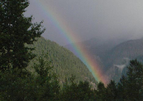
At Cherryville, a turn onto Sugar Lake Road is where the river turns north into its headwaters area. It follows the valley bottom where it arrives at Brenda Falls and Sugar Lake. Monashee Provincial Park, the Mark Berger Traverse, The Pinnacles, and Rainbow Falls are a few places where the adventurous will explore the mix of old growth rainforests and waterfalls with the alpine and rock landscape found at the top of these mountains.
This is a more rugged and secretive landscape that marks the difference between the hills and manicured bottomlands that holds the human population of the Okanagan and Shuswap. Here the foothills that lead to the mountains are steep with deep ravines and hidden highlands, all of it defining the greater idea of a pristine British Columbia.
A ribbon of homesteads turned retreats border this country road. The population is mixed with loggers, ranchers and those who would be hippies many of them, folks retreating from a busier outside world. They share a playground that is being discovered by the greater Okanagan, and they also share another precious resource that remains locked in this rugged landscape; the locals would interrupt anyone with a thirsty notion - and they would be quick to say – “We own this water here, and we will protect it forever”.
This war cry becomes confirmed to weekend visitors who are welcomed by spray-bombed signs along the road that shout “Say No to Sugar Lake Development!”
Strange bedfellows are evident indeed, since this is also the land that BC Hydro made. This place is the overlay of who we have become - and has now left us the question - who do we want to be in the future?
Two dams lock the upper Shuswap from its former self, and between them is a white water section called The Chute which causes even the bravest of canoeists and kayakers to avoid this part of the river completely, choosing to use a portage over a rocky knoll.
Wilsey Dam at Shuswap Falls and Brenda Falls Dam which holds back Sugar Lake are all examples of the small hydro electric projects that were built in the 1940’s. Back then there was little understanding of environmental impacts or even cultural ones. This is a place where salmon live only in spirit since they can no longer pass through the concrete gates at Shuswap Falls.
Sugar Lake represents the farthest reach for vacation development in the Okanagan, at least in these parts. In 90 minutes Kelownians have found that they can rid themselves from summer traffic and tourists and gather in a place with other like minds.
As the washboard road meanders past Sugar Lake, RV’s dot the road corridor and ATV’s navigate with traffic. This is a lawless land, and most like it that way. A stalled trail bike a long way from no-where becomes a social magnet for off-road ceremony as others gather, all eager to share a story of repairs or long walks back to camp amidst invisible bears.
Maybe they’ll get that bike going, maybe they won’t. We waved as we passed by, they waved back. I said to Doug, “I hope we don’t see too many more of them,” referring to the universal noise they carry with them.
Few venture farther past the Monashee Provincial Park turnoff, and that’s a good thing because the road can’t take many more trips. Washboard and slides can cause a road to reach a critical mass of destruction that could claim a life or two, if you should be in the wrong place at the wrong time when rocks decide to shift.
Our destination is to navigate up one of the final tributaries of the Shuswap and we had arrived at a couple of choices. There was a headwaters area coming from the slopes of Joss Mountain that met another creek coming from Davis Mountain, then along the western slop of the headwaters area was a drainage from Tsuis Mountain which had Valerian Creek dropping down to the river. Collectively these large creeks would come together and form the river in the vicinity of Greenbush Lake.
As the Jeep turns passed a blind corner we suddenly surprise two moose on the road. Immediately in front of us, they begin to gracefully place some distance between themselves and us. We slowed down to a near stop to adjust camera equipment but our delay was to the benefit of long majestic strides met by a steep embankment that allowed the moose to disappear into the shadows of the forest. They were magnificent animals, healthy and mature and seemed to represent their presence well as a dominant species in this landscape.
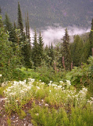
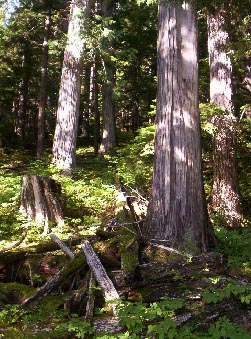
This was only the beginning of nature’s road show as the closed-in second growth forest that defined the road corridor finally began to open up and unveil mountain peaks. The road was beginning to drop into the valley bottom and in places the forest was now transforming into old growth Douglas Fir and Cedar, we were now making our way through an ecological reserve. According to our GPS we were now within the expanded Monashee Provincial Park boundaries or at least new protected areas. On each side of the road small clearcuts appeared and within them a few tall stumps called wildlife trees are left. They stand like Druid symbols and seem strange to us as they appear as though they may be ineffective as woodpecker habitat. The ground is littered with debris.
Doug comments that it’s more like an industrial park than a provincial park.
Here the Shuswap River is a dwarf of its former self, only a few more tributaries exist this far upstream and we will attempt to navigate one of them. A fork in the road suggests that we need to make a choice, given that we were trying to follow the Shuswap to its source. Joss Mountain was going to be a challenge, the steep climb would be hindered by a great deal of bushwacking and poor weather was closing in. Upon another study of the topo maps we could see that an old Forest Service Road came close to the creek and may cut some time and effort off the trek
We meandered up a very steep logging road, after a few switchbacks we found the road entrance that would lead us to the creek, but to our dismay it was blocked by logging equipment. The drive now turns into a trek and one that will take much longer than we thought, and clouds have darkened the sky.
A long walk, a disappearing road and finally a dry creek bed had us finally discover that anything beyond was severe bushwhacking, and now we would be fighting the weather. Sometimes I curse the photo part of these assignments, as photos require a visual environment that can tell a big part of the story; now as the rain and sleet falls upon us, this story was turning into a fog of imagery.
As the first drops of rain fell out of the sky we knew that there would be a slim chance of reaching water from this approach, our only choice now was to backtrack and take another fork in the road to Valerian Creek.
We found Valerian Creek tumbling fairly close to the road. In Latin the word means “strong and healthy”. It’s also associated with the name of a plant that goes back to the time of the Greeks and Romans; in BC, Sitka Valerian with its towering white flower will be growing in the vicinity of the creek.
It’s as though whoever named this creek, was very conscious to give this beautiful place its proper name. In medieval Sweden, valerian flowers were sometimes placed in the wedding clothes of the groom to ward off the "envy" of the elves.
Yes, elves could be here.
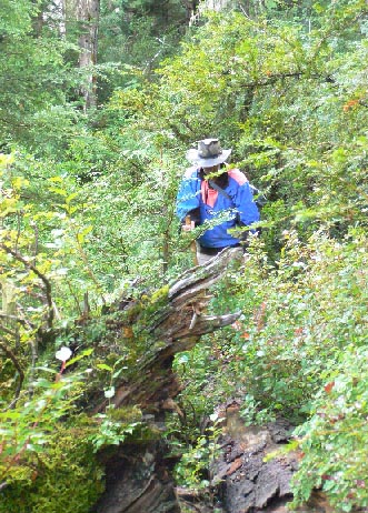
The plant is also considered an effective remedy for the reduction of anxiety, which in the midst of a downpour would have been helpful to have on hand. Navigating upstream required us to climb through dense underbrush up the side of the creek which was now a series of torrent waterfalls. The creek corridor was protected by a natural ravine that had within it a dense stand of prickly Devils Club, but a large tree had fallen across part of the ravine allowing us to circumnavigate above the club. It was slippery and it was hard to determine just how serious a slip into the ravine might be.
“How deep do you think this is I asked?”
“Just as deep as the Devils Club is tall” Doug replied. This hardly seemed helpful. I crouched down and tried to find solid earth with the end of my walking stick. None could be found.
Doug and I agreed that a spill into the ravine coupled with the extreme density of the painful plant would certainly mean injury and if one of us spilled over - the other would carry on and finish the story.
Traversing the log ended up being a success, we then found ourselves sheltered from the downpour by a rich lush rainforest which could only be described as otherworldly. A thick blanket of moss reached to the edge of boulders that held in place the torrent of cascades that fed through this steep ravine and surrounded it with mist and thunder.
The whitewater poured a freshness that created pure oxygen that provided the lushness to this place and created a mountain oasis that seemed to mark the beginning of things, perhaps life, perhaps God, perhaps simply water.
This water I would drink and the risk would be worth it. Loose moss met the edge of slippery rocks placed by the random acts of weather and gravity over thousands of years. My footprint would be an intervening and memorable moment for any rock that could talk.
I will try to be careful.
A strange combination of balance and crawling aided by wedging my walking stick between the stones I slowly made my way between the rocks and over them. Doug followed but kept an eye for an easier way, his mission was one of a summit, not a drink. By this time we were both soaked, the extreme mist combined with the downpour seemed to remove any fear that we had for stepping into the water and getting feet wet.
A cascade emerged from the many that seemed to define nature’s perfection as she delivers water from a mountain. A stone shelf protruded into the waterfall like an alter stone; the water then spread itself into a variety of clear fingers all flowing like a series of natural faucets. It’s as though the water wanted to be shared with those who had captured the prize of this place.
I would take a drink here.
Within my camera bag was a pocket that contained two small brandy glasses carefully packed to withstand a stumble or two, eager to share a glass with Doug a few yards away, he waved a decline due to the difficult proximity between where he was, and the alter. Navigating a glass of water to him in the rain seemed somewhat too surrealistic for the moment. Doug was soaked, I could read his mind – clearly he did not want a glass of water, and he was sending me telepathic signals that any continuation upstream would define this route as the pneumonia trail.
So I would drink alone at the alter.
I carefully held the glass as to catch simply an edge of a splash of water tumbling over the rock. I had a brief and fatal notion of the force breaking the stem, cutting my hand and introducing a stream of blood into the channel, turning this into a more biblical moment of initiation and fate. But all went well; I held the glass up to the sky. It caught droplets of rain as the mist coated the glass. There was no aroma, only a fullness of purity as I took a swig. The soft flavour of nothingness defined perfection – this was good water.
I victorious moment for sure, at the corner of my eye I caught Doug a few yards away shaking his head at the drama of it all.
Now being soaked, cold and in a precarious position with a brandy glass on a slippery rock on the edge of a waterfall that could certainly provide all of the elements of a fatal head injury, I thought once again about the story – yes the spiritual moment was over and done – mission accomplished.
Now, I was thinking about how the magazine would explain a disclaimer – don’t try this at home – don’t drink water from a creek or lake – don’t carry a stemmed glass up the side of a waterfall – don’t climb over wet slippery rocks or logs high up in the air – and don’t walk into remote places where there might be grizzly bears.
Yes, I will do this again soon, “Com’on Doug lets get back to the Jeep”, but Doug couldn’t hear me, the Valerian cascade was too loud and he had already put some distance between my pondering and a warm, dry vehicle.
It was a perfect time to go home.
(30)