It is here that the Okanagan grasslands, forests and mountains are bound together by the sustenance of life – water. Exploring this eastern edge of the North Okanagan provides adventurers a chance to find worlds hidden within the remote valleys of this place.
This two part Bearfoot Canada series has been produced by the Watershed Intelligence Network in partnership with the Cascadia Conservancy.
PART 1
We welcome you to explore with us the Undiscovered Country, a documentary featuring stories and experiences as we journey into the Coldstream and Monashee.
The Undiscovered Country is a production of the Watershed Intelligence Network.
The Watershed Intelligence Network creates and manages information power tools for a changing planet. Watershed produces online documentaries for broadcast within its own online network as well as other independent and publically owned media outlets.
This documentary series was made possible through individual contributions and sponsorship support by community owned businesses and not-for-profit foundations.
If you would like to support the Watershed Intelligence Network please visit our contribute page.
The content within this documentary series cannot be reproduced without written permission from the Watershed Intelligence Network – please contact us.
This online documentary is available for viewing from September 23rd
to November 30th 2009
The Cascadia Conservancy promotes a healthy and sustainable environment for rural British Columbia. We link the protection and enhancement of natural eco-systems with human settlement that includes a vibrant local economy.
We are a proud partner of this production The Undiscovered Country
Stewardship & Community
Find our latest productions in our program guide called Cafe.
PART TWO
Begins October 15th
Mistical Sacred Places
Top of the Kettle
Gold Fever & Ghosts
Airheads in Flight
Landscape at Risk
Kids Travel Pack
7 Days of Adventure
our sponsors
Deuling & Company Lawyers
Hodge & Associates
Reality Based Accounting
Cozy Cabins Nature Resort
Bloom Wellness Centre
Keefer Lake Resort
Miracles & Hair Design
Dott’s Chocolate Shop
M-T Ranch WoodCraft
Doug Brown
Chartered Accountants
The Wildcraft Forest
The Cascadia Conservancy
Elzer Family Community
Media Fund
Westcoast CED Consulting Ltd.
Please support our sponsors who made this documentary series possible.
Maps
Getting Here, Downloads, Weather and Facts
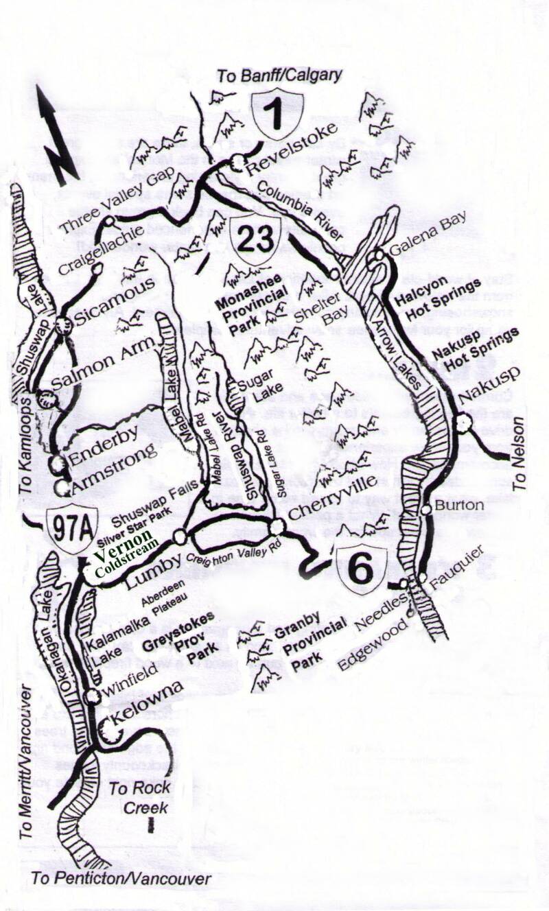
A journey to the Coldstream and Monashee can begin by following Highway 6 which begins from Highway 97 in Vernon which is located in the beautiful North Okanagan in the province of British Columbia, Canada. By travelling 25km east of Vernon on Highway 6 you find the Village of Lumby, considered the Gateway to the Monashee. Approximately 20km east of the Village of Lumby you will find the beautiful and peaceful countryside of Cherryville.
From Cherryville, Highway 6 meanders through the Monashee to Edgewood which is located on the Arrow Lakes where you will cross the lake by ferry at Needles (this is a free crossing). Once you cross the lake you will find the communities of Fauquier and Burton before you begin in a northward direction to the hotspring communioty of Nakusp.
Continuing north from Nakusp you will again cross the lake at a free ferry crossing. Continueing north you will arrive at Revelstoke a small and picturesque city located on the TransCanada Highway, from here access east will lead you to Calgary, while west you can complete a circle drive back to Vernon in the Okanagan, or continue west to Kamloops and Vancouver.