It is here that the Okanagan grasslands, forests and mountains are bound together by the sustenance of life – water. Exploring this eastern edge of the North Okanagan provides adventurers a chance to find worlds hidden within the remote valleys of this place.
This two part Bearfoot Canada series has been produced by the Watershed Intelligence Network in partnership with the Cascadia Conservancy.
PART 1
MAPS
Map Links and route downloads. Explore roads and trails
Click Here
We welcome you to explore with us the Undiscovered Country, a documentary featuring stories and experiences as we journey into the Coldstream and Monashee.
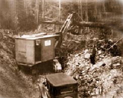
It was a mega project during its day and the longest irrigation system in BC eventually covering 46km. The White Valley Irrigation and Power Company was set up in 1907 to further develop and operate the system which allowed the Coldstream Ranch to subdivide smaller holdings for orchards. Eventually promoters would claim that 20,000 acres were irrigating lush orchard land and green hay fields.
Consumers paid for the amount they used through a metering process. By 1923 there were 23 ditchwalkers and foremen employed to make the continuous repairs, checks and operations along the system. These same workers would eventually be called water bailiffs charged with the task of raising and lowering the gates at Aberdeen Lake, a job eventually tasked by remote technology.
Water primed the first real estate boom in the Okanagan. In many cases land developers with limited capital outlay, constructed temporary wooden flumes in order to start their subdivisions. Most of these irrigation systems had a lifespan of only eight to ten years. Development companies expected that land profits would provide capital to replace the wooden flumes with concrete ones, but with the arrival of the Depression in 1913 and then the Great War, few companies remained solvent enough to deliver such intentions.
As a result, by 1916, the Okanagan Falls Water and Irrigation Company, the Kelowna Irrigation Company, and the South Kelowna Irrigation Company had all failed and gone bankrupt placing fruit growers with a disappearing water source and in a state of crisis. Growers became organized and called on the government to take action. Eventually, the government would step in to untangle the mess created by privately held irrigation companies, eventually replacing them with public irrigation districts; a process that took several years. After a century the possibility of a water shortage, still strikes fear into the agriculture industry.
The Grey Canal withstood the test of time, today, the wooden flumes and concrete ditches are replaced with pipes feeding drip irrigation and micro-sprinklers which have greatly reduced the water required to grow crops. This allows more crop production while using the same water. Gains from conservation have also helped to protect ecosystems such as streams.
For the Grey Canal, silence surrounds the bones of the old flumes which can still be seen surrounding Vernon; ditchwalkers have now given way to hikers who are eager to walk the route of the old canal, part of which, has become designated as a heritage trail.
(30)
The Grey Canal
Water giving life to the valley
By Don Elzer
For many thousands of years, the Okanagan Valley was the undisputed home of the Interior Salish. Early in the 19th C., fur traders used their trails along Okanagan Lake to export furs from the area to the outside world. By the 1860’s, gold discoveries had brought miners and missionaries to the valley. Settlers soon followed and land was pre-empted for ranches. Wagon roads soon replaced the old pack trails, and, with the arrival of a branch line of the CPR in 1892, settlers were able to reach the larger markets outside the Okanagan Valley. Improved transportation led to increased immigration and soon the large ranches were being sub-divided into smaller holdings. Major irrigation schemes allowed for the intensive planting of orchards and field crops.
In the North Okanagan, Lord Aberdeen who would eventually become Canada’s Governor General would begin to mastermind the Grey Canal Irrigation Project when he bought the Coldstream Ranch in 1891. According to historian Ann M. Davis the canal supplied water from the Duteau Creek watershed using Haddo and Aberdeen Lake as reservoirs. Water dropped from an altitude of 1900ft. down to the Coldstream Valley and Okanagan Landing.
By 1908, a reported 1,000 fruit trees were planted in the Okanagan Valley and land prices had risen from $1 to $150 an acre. A supply of water was ensured with the construction of irrigation systems like the Grey Canal.
a vision of prosperity
& unforseen risk..
our sponsors
Deuling & Company Lawyers
Hodge & Associates
Reality Based Accounting
Cozy Cabins Nature Resort
Bloom Wellness Centre
Keefer Lake Resort
Miracles & Hair Design
Dott’s Chocolate Shop
M-T Ranch WoodCraft
Doug Brown
Chartered Accountants
The Wildcraft Forest
The Cascadia Conservancy
Elzer Family Community
Media Fund
Westcoast CED Consulting Ltd.
Please support our sponsors who made this documentary series possible.
The Undiscovered Country is a production of the Watershed Intelligence Network.
The Watershed Intelligence Network creates and manages information power tools for a changing planet. Watershed produces online documentaries for broadcast within its own online network as well as other independent and publically owned media outlets.
This documentary series was made possible through individual contributions and sponsorship support by community owned businesses and not-for-profit foundations.
If you would like to support the Watershed Intelligence Network please visit our contribute page.
The content within this documentary series cannot be reproduced without written permission from the Watershed Intelligence Network – please contact us.
This online documentary is available for viewing from September 23rd
to November 30th 2009
The Cascadia Conservancy promotes a healthy and sustainable environment for rural British Columbia. We link the protection and enhancement of natural eco-systems with human settlement that includes a vibrant local economy.
We are a proud partner of this production The Undiscovered Country
Stewardship & Community
Find our latest productions in our program guide called Cafe.
PART TWO
Begins October 15th
Mistical Sacred Places
Top of the Kettle
Gold Fever & Ghosts
Airheads in Flight
Landscape at Risk
Kids Travel Pack
7 Days of Adventure
Map Links and route downloads. Explore roads and trails