ELLISON RIDGE TRAIL Located on the west side of Kalamalka Lake starting from Highway 97 and Old Mission Road at Oyama and ending in Vernon.
COUGAR CANYON TRAIL Located on the east side of Kalamalka Lake beginning in Oyama and ending at the Kalamalka Lake Provincial Park boundary.
HIGH RIM TRAIL Begins in Kalamalka Lake Provincial Park running south to Oyama Lake Road then to Postill Lake Road, then to James Lake Forest Service Road, ending at Highway 33.
OKANAGAN LAKE, KALAMALKA LAKE
ENDERBY CLIFFS TRAIL From Mabel Lake Road and Brash Allan Road in Enderby, the Enderby Cliffs Trail including the summit.
SHUSWAP RIVER From the upper Shuswap at Greenbush Lake to, and including Sugar Lake then to Mabel Lake, to Kingfisher then to Enderby.
MABEL LAKE
GRAYSTOKES PLATEAU From Graystokes Road to the Graystokes Plateau Trail System to Buck Mtn. to Buck Hills Rd to the Aberdeen Plateau and including Ferry Lake.
UPPER GRANBY DRAINAGE From the Kettle River Forest Service Road to Winnifred Creek Road to Lightning Peak Route Trail at the north end of Granby Provincial Park
SHUSWAP RIVER From the upper Shuswap at Greenbush Lake to, and including Sugar Lake then to Mabel Lake, to Kingfisher then to Enderby..
CAMELS HUMP TRAIL From Creighton Valley Road and Cleir Lake Road to Camels Hump Trail and including the Camels Hump summit.
SAWTOOTH RANGE From Mabel Lake Rd and Taylor Creek Road to Park Mountain, then along the Sawtooth Range Ridge to Tsuius Mountain Trail to Tsuius Mountain, Mount Mabel and Joss Mountain including the drainage to Cottonwood Bay on Mabel Lake, and the Joss Mountain Trail down to Greenbush Lake.
RAINBOW FALLS TRAIL From Sugar Lake Road to the Rainbow Falls Trail to border of Monashee Provincial Park and including Rainbow Falls.
THE PINNACLES From North Fork Road in Cherryville to the Twin Lakes Trail including Twin Lakes, then to the Mark Berger Traverse to Monashee Lake which meets the Monashee Lake Trail ending at South Fork Road. From South Fork Road to the Pinnacles Lake Trail including Pinnacles Lake; and Vista Pas Trail and the Barnes Creek Trail which ends at Fife Creek Road which turns into Keefer Lake Road.
KALAMALKA LAKE, MABEL LAKE, SUGAR LAKE
BLUE GROUSE MOUNTAIN TRAILS From Bear Creek Road, the Blue Grouse Mountain Trail System including the summit.
McDOUGALL RIM TRAIL SYSTEM From McDougall Creek Road, the McDougall Rim Trail System including the summits of Carrot Mountain and Mount Hayman.
OKANAGAN LAKE
HIGH RIM TRAIL Begins in Kalamalka Lake Provincial Park running south to Oyama Lake Road then to Postill Lake Road, then to James Lake Forest Service Road, ending at Highway 33.
GRAYSTOKES PLATEAU From Graystokes Road to the Graystokes Plateau Trail System to Buck Mtn. to Buck Hills Rd to the Aberdeen Plateau and including Ferry Lake.
KALAMALKA LAKE
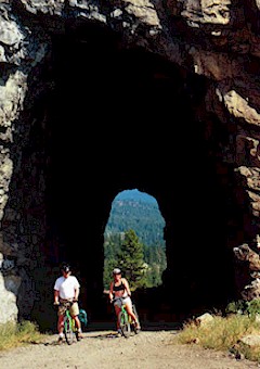
McCULLOCH Kettle Valley Railway (KVR) Trail south to Myra Canyon then south to Naramata.
McCULLOCH Includes the X-country Ski Trails and Minnow Lake Trail.
OKANAGAN LAKE
KVR OKANAGAN RIVER TRAIL Beginning at Okanagan Falls the Kettle Valley Railway Trail to Osoyoos. Including an ancillary trail route to McIntyre Bluff including the summit.
KVR OKANAGAN RIVER TRAIL Beginning at Okanagan Falls the Kettle Valley Railway Trail to Osoyoos. Including an ancillary trail route to McIntyre Bluff including the summit.
MOUNT KOBAU TRAILS From Kobau Lookout Road, the Mount Kobau Trail System including the summit.
CENTENNIAL TRAIL Access from Ashnola River Road to Easy Going Creek Main into Cathedral Provincial Park via Wall Creek Trail which links to Centennial Trail which leaves the park at Ewart Creek and continues on Crownland to Joe Lake.
KVR TROUT CREEK TRAIL From Penticton, the Kettle Valley Railway Trail to Summerland, then to Princeton, ending at Tulameen and Otter Lake.
KVR NARAMATA CHUTE LAKE TRAIL From Penticton, the Kettle Valley Railway to Naramata, Chutelake and then on to Myra Canyon with ancillary trails to the Okanagan Mountain Provincial Park Boundary.
OKANAGAN LAKE
Bearfoot Route Index
Helping travelers understand
travel fear and the unknown.
*
monster
the
guide
Bearfoot Canada is your travel portal to unique and exciting Canadian experiences. Visitors can explore nature, adventure and culture on one of the many Bearfoot Routes throughout the British Columbia Interior. Walk, bike, canoe or drive The Canadian Desert; The Monashee; The Golden Mile and more....
If the Cultural Corridor were a symphony, then the North Okanagan would be a lush, sweeping passage of cello and viola, as rich and sustaining as fertile soils and verdant green fields and forests. Extending from Enderby and Cherryville in the north and east to Oyama in the south, this is a place to pause and linger as you indulge your craving for landscape vistas. Turquoise lakes sparkle at the foot of gently sloped hills, dotted with wild-flowers in spring and furry with low grasses for the rest of the year, looking for all the world like the flanks of some huge and benign animal at rest. Backroads, small towns and warm hospitality will lure you out of the
mainstream and into a charmed world full of creativity.
Here, history surrounds you - outside the museums, it may take the form of a mural, an outdoor stage on a moonlit summer night, the taste of artisanal cheese or a four-legged friend with a heritage pedigree. There are stories for telling and retelling. Make them your own and take them with you.
Give yourself permission to slow down and let your senses explore. Inhale the fragrance of sun-warmed fruit. Gaze into the mystery of an Okanagan opal. Stroll along the banks of the Shuswap River and open your mind to the thoughts that come with the sound and sight of water in movement. Seek out the beauty that's created just for you. And above all, watch for magic. It is in the very air.
Central Okanagan
The Central Okanagan, extending from Lake Country in the north to Peachland in the south, offers urban amenities and rural ambience as theme and variation. A 15 minute drive in any direction will take you from a chic downtown gallery to orchards, vineyards and grassy hillsides populated by California quail and tall Ponderosa pines, all with the sparkling backdrop of a 120km long fjord lake.
Kelowna's Cultural District is a Cultural Corridor highlight and the tempo here is molto vivace, with public and commercial art galleries, artist studios, performance venues, museums and a lively assortment of dining, entertainment and shopping options.
A walking tour through the district will take you from palate to palette with everything from Icewine to Haida ceremonial masks and canvasses by internationally acclaimed artists.
Intriguing grace notes will beckon from beyond the Cultural District. You may hear melodious bells from an elegant winery tower high above an ancient volcanic mound. It might be the fragrance of apple blossoms, lavender or gently oak-aged Chardonnay. Maybe it's the bold glint of stainless steel sculpture on a sunlit hillside or the lure of the past in elegant gardens and architecture. Or perhaps it's curiousity about how artists interpret the world, best served by a trip to a rural studio to watch creativity at work.
Listen for the murmur of stories; they may be in an apple, a glass of wine, or the walls around you. Wherever your senses and curiousity lead you, enrichment and the pleasures of discovery await.
South Okanagan/Similkameen
There is a sense of mystery and contradiction in the shimmering desert air. All is not what it seems. This sun-drenched landscape reveals wonders as subtle as a tiny desert flower or as dramatic as a pendulous golden moonrise over white silt cliffs which seem to pulse and glow against the deep blue of sky and lake. The enduring beauty of this fragile area will haunt you like a musical motif wafting on a cool breeze.
Extending from Summerland in the north to Osoyoos at the US border, the Corridor's southern reaches are inspired by water, sun and soil. Past, present and future thrive in the knowledge and artistry of aboriginal peoples. Museums and heritage sites tell the stories of settlers lured by precious metals and the promise of agricultural bounty, and beautifully restored testaments to their toil and vision remain.
The seasons take delightful form in gardens, wines and produce. Where better than a farmers' market to engage in the elemental pleasure of biting into a sun-warmed apricot. Gardens and vineyards are dramatic here, perched alongside Okanagan Lake, above plunging canyons, or sweeping along the famed benchlands.
Soil makes it way into an extravagance of ceramic art and painters fill their canvasses with imagery from nature. Wherever you go, water, sun and soil will bestow their blessings. Tread with care on this precious land.